Japan's Daichi Satellite Measures Earthquake Effects
Credit: JAXA
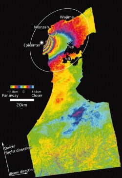
Japan's Advanced Land Observing Satellite "Daichi" produced this image depicting a rise of as much as 45 cm. (18 in.) in land-surface levels following the Noto Peninsula earthquake of Mar. 25. From the offshore epicenter, each cycle of colors represents a rise of 11.8 cm., as measured by the...
Subscription Required
This content requires a subscription to one of the Aviation Week Intelligence Network (AWIN) bundles.
Schedule a demo today to find out how you can access this content and similar content related to your area of the global aviation industry.
Already an AWIN subscriber? Login
Did you know? Aviation Week has won top honors multiple times in the Jesse H. Neal National Business Journalism Awards, the business-to-business media equivalent of the Pulitzer Prizes.