Satellite Imagery Shows Open Northwest Passage
Credit: TERRY HARAN/NATIONAL SNOW AND ICE DATA CENTER
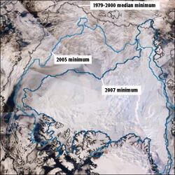
This mosaic satellite image of the Arctic ice north of Canada, collected Sept. 15-16 by Modis on NASA’s Terra Earth-observation satellite, shows the retreat of the ice at summer’s end from the 1979-2000 median (gray line) to 2005 (light-blue line) to this year (dark-blue line). Relatively clear mid...
Subscription Required
This content requires a subscription to one of the Aviation Week Intelligence Network (AWIN) bundles.
Schedule a demo today to find out how you can access this content and similar content related to your area of the global aviation industry.
Already an AWIN subscriber? Login
Did you know? Aviation Week has won top honors multiple times in the Jesse H. Neal National Business Journalism Awards, the business-to-business media equivalent of the Pulitzer Prizes.